
Aerial Property Photos: Why Drone Photography Improves Listings in St Helena Bay
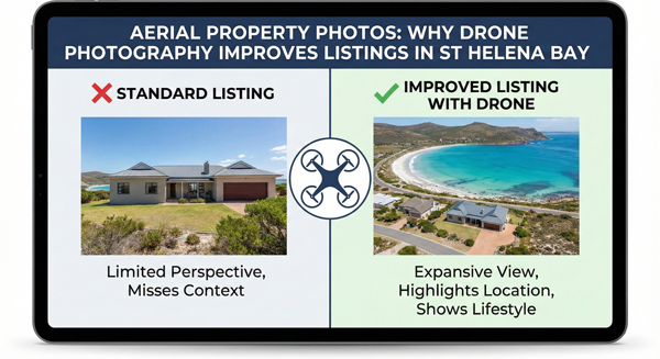
Property listings succeed or fail long before a viewing is booked. Buyers decide which homes deserve attention within seconds of seeing them online. In coastal markets like St Helena Bay, where many properties share similar architecture, finishes, and price ranges, the type of imagery used often matters more than the quantity.
Aerial property photos have become one of the most effective tools for improving listing performance in this environment. Not because they are dramatic, and not because they are fashionable, but because they answer questions that buyers struggle to resolve from street-level photos alone.
This article analyses how buyers behave when viewing aerial images, why drone photography provides context that ground-based photos cannot, how aerial photos increase time-on-listing, and why they are one of the most reliable ways to differentiate similar listings in St Helena Bay and across the West Coast.
The Core Problem: Buyers Struggle to Understand Context
Most property listings are built around interior photography. Kitchens, living rooms, bedrooms, and bathrooms dominate the image set. While these images are important, they leave a critical gap.
They show what the home looks like, but not where it sits.
Buyers often struggle to understand:
• How close neighbouring homes are
• How the plot relates to surrounding streets or open land
• Whether the area feels dense or spacious
• How the home fits into the broader setting
When this context is missing, buyers must guess. Guessing creates uncertainty, and uncertainty reduces engagement.
How Buyers Actually View Aerial Images
Buyers do not view aerial images as decorative extras. They use them strategically.
When buyers encounter an aerial photo, they instinctively zoom out mentally. They stop looking at rooms and start evaluating position, orientation, and surroundings.
Typical buyer questions triggered by aerial photos include:
• How private is this property
• How far is it from neighbouring houses
• What surrounds the home beyond the boundary
• Does the location suit my lifestyle
Aerial images shift buyer attention from features to fit.
This shift is critical for decision-making.
Buyer Behaviour Changes When Context Is Visible
When buyers can see context clearly, their browsing behaviour changes.
They spend more time evaluating the listing. They compare it more carefully with others. They form stronger opinions earlier.
Listings with aerial images tend to move buyers from casual browsing into deliberate consideration.
This is a key reason aerial photography improves listing performance.
Why Street-Level Photos Are Limited
Street-level photos provide only a narrow slice of reality.
They are constrained by:
• Viewing angle
• Physical obstructions
• Perspective distortion
• Selective framing
While they can show façade and curb appeal, they rarely explain how the property sits within its environment.
In coastal towns like St Helena Bay, where value is closely tied to space, openness, and surroundings, this limitation is significant.
Aerial Photos Solve the Orientation Problem
Orientation is one of the hardest concepts to communicate in property marketing.
Buyers want to understand:
• Where the property sits relative to the street
• How it aligns with surrounding homes
• Where open space begins and ends
• How boundaries relate to the environment
Aerial photos solve this instantly.
From above, relationships become obvious. Buyers no longer need to infer or imagine.
Context Is More Than Location Pins
Maps show location. Aerial photos show context.
Context includes:
• Density of the neighbourhood
• Character of surrounding properties
• Presence of open land or natural features
• Spatial breathing room
These factors influence buyer perception far more than distance alone.
Aerial photos make these factors visible at a glance.
Why Drone Photos Increase Time-on-Listing
Time-on-listing is a strong indicator of buyer interest and engagement.
Listings with aerial images often see longer browsing times because buyers pause to study them. Aerial photos invite inspection rather than quick judgement.
Buyers often:
• Zoom in and out
• Compare boundaries
• Examine surroundings
• Revisit the image after viewing interiors
This additional interaction increases total time spent on the listing.
Longer time-on-listing correlates with higher enquiry likelihood.
The Psychology of Spatial Understanding
Humans feel more comfortable when they understand space.
When space is unclear, buyers feel cautious. When space is clear, buyers feel oriented.
Aerial photography improves spatial understanding by showing scale and relationship directly.
This clarity reduces mental effort and increases confidence.
Scale Is Easier to Grasp From Above
Scale is difficult to judge from interior or street-level photos.
Aerial photos show scale through comparison. Buyers can see how large the plot is relative to neighbouring properties, roads, and open areas.
This visual comparison is intuitive. Buyers do not need measurements to feel whether a property is spacious or compact.
Feeling scale matters more than calculating it.
How Aerial Photos Influence Perceived Value
Perceived value is shaped by context as much as by finishes.
A modest home on a spacious, well-positioned plot may feel more valuable than a larger home in a dense setting.
Aerial photography allows buyers to make this judgement accurately.
When context supports value, buyers are less resistant to price.
Differentiation in Similar Listings
In St Helena Bay, many listings share similar interior features.
What differentiates them is often:
• Plot position
• Surrounding openness
• Relationship to neighbouring homes
• Overall setting
Aerial photos make these differences visible.
Without aerial images, listings blur together. With them, each property gains a distinct identity.
Visual Differentiation Drives Better Comparison
Buyers compare listings visually before comparing prices.
Aerial images give buyers a new dimension for comparison.
Instead of comparing only kitchens and bathrooms, buyers compare space, context, and setting.
This deeper comparison leads to more informed enquiries.
Drone Photography as a Transparency Signal
Aerial photos signal transparency.
They show boundaries, surroundings, and context without selective cropping.
Buyers interpret this openness as honesty.
Honest presentation builds trust, even when a property is not perfect.
Why Transparency Improves Listing Credibility
Listings that feel transparent attract more serious buyers.
When buyers trust what they see, they are more willing to engage, ask questions, and book viewings.
Aerial photos reduce suspicion and lower perceived risk.
Out-of-Town Buyers Rely on Aerial Context
Many buyers interested in coastal properties are not local.
They rely heavily on visuals to decide whether a viewing is worth the trip.
Aerial photos provide reassurance by showing the setting clearly.
This leads to higher-quality enquiries from buyers who already understand the location.
Drone Photos as a Buyer Filter
Aerial images act as a filter.
Buyers who dislike the context may disengage early. Buyers who appreciate it engage more deeply.
This filtering improves enquiry quality and reduces wasted viewings.
Why Aerial Photos Feel Calm Rather Than Promotional
Well-executed aerial photography is calm.
It does not rely on dramatic angles or exaggerated perspectives. It simply shows the truth from above.
This calmness aligns with how buyers want to make decisions.
Overly promotional imagery creates scepticism. Calm imagery builds confidence.
The West Coast Buyer Mindset
Across the West Coast, buyers are increasingly visually literate.
They expect to see how properties relate to their surroundings.
Listings without aerial photos now feel incomplete, especially in lifestyle-driven areas.
Meeting this expectation protects perceived value.
How Aerial Photos Support Pricing Confidence
When buyers understand context clearly, they are less likely to challenge price based on uncertainty.
Aerial photos align expectations with reality.
Aligned expectations lead to smoother pricing conversations.
Aerial Photos vs Aerial Video
Aerial photos and aerial video serve different roles.
Photos allow inspection and comparison. Video explains movement and flow.
For listing performance, aerial photos are often the first and most accessible layer of context.
They load quickly, display well across platforms, and invite detailed examination.
Platform Compatibility and Performance
Most property platforms prioritise images.
Aerial photos integrate seamlessly into listing galleries, thumbnails, and featured images.
They enhance performance without requiring additional user action.
This accessibility contributes to their effectiveness.
The Cost of Omitting Aerial Photos
Listings without aerial photos often suffer from:
• Shorter browsing times
• Lower engagement
• Weaker differentiation
• Increased buyer uncertainty
These costs are rarely obvious, but they accumulate.
Why Aerial Photography Is a Strategic Choice
Including aerial photography is not about upgrading visuals.
It is about improving communication.
Clear communication reduces friction, builds trust, and improves outcomes.
What Buyers Remember
Buyers remember listings that helped them understand quickly.
They forget listings that felt confusing or incomplete.
Aerial photos contribute to memorability by providing a clear mental map of the property.
Reframing Drone Photography as Information
Drone photography works best when framed as information, not spectacle.
Its value lies in clarity, not drama.
When used this way, it consistently improves listing performance.
Practical Guidance for Sellers and Agents
When reviewing aerial property photos, look for:
• Clear boundary visibility
• Honest representation of surroundings
• Balanced perspective without distortion
• Calm, neutral composition
These qualities indicate that the images are serving buyers, not marketing hype.
Practical Guidance for Marketers
For marketers, aerial photography should be planned around buyer questions.
What would a buyer want to know about this location that photos from the ground cannot show?
Answering that question guides effective aerial capture.
Buyer Psychology and Confidence
Confidence grows when uncertainty shrinks.
Aerial photos shrink uncertainty by making the unseen visible.
Confident buyers engage more deeply and act more decisively.
Closing Perspective
Aerial property photos improve listing performance in St Helena Bay because they solve a fundamental problem in property marketing: lack of context. They show where a property sits, how it relates to its surroundings, and how it compares spatially to others.
Drone photography changes buyer behaviour by increasing engagement time, improving differentiation, and reducing uncertainty. It allows buyers to move from casual browsing to informed consideration.
In coastal markets like St Helena Bay and across the West Coast, buyers are not just choosing a house. They are choosing a setting.
Aerial photography makes that setting clear.
When context is clear, confidence follows.
