Why Drone Photography Transforms Property Marketing in Paternoster
Property marketing in Paternoster operates on a different emotional wavelength to most towns. Buyers are not only evaluating square metres and finishes. They are evaluating atmosphere, setting, and how a property sits within a very specific coastal environment. This is why traditional ground-level photography, while still essential, often fails to communicate the full value of a property in this area.
Drone photography changes that dynamic completely.
In Paternoster and across the West Coast, aerial imagery has become one of the most powerful tools in modern property marketing because it aligns with how buyers actually assess coastal homes. It provides context, orientation, and perspective that ground photos simply cannot deliver on their own. More importantly, it reshapes how buyers perceive quality, desirability, and value.
To understand why drone photography is so transformative, it helps to look at how buyers behave, what they struggle to understand from standard listings, and how aerial perspective fills those gaps.
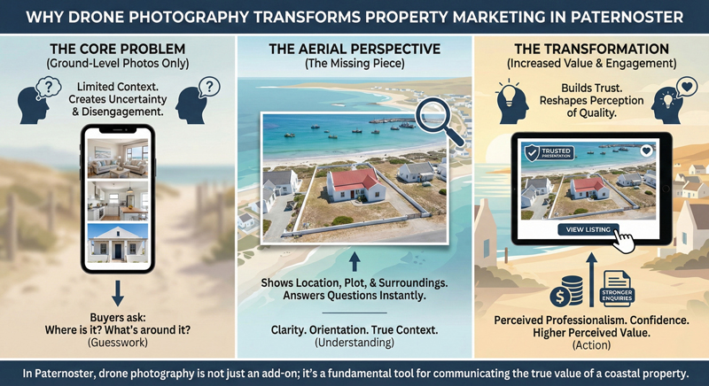
The Core Problem With Traditional Property Marketing
Most property listings are built from the inside out. Interiors are shown first, followed by a front façade and perhaps a garden. This approach assumes that buyers already understand where the property is and what surrounds it.
In Paternoster, that assumption rarely holds true.
Buyers often browse listings remotely before visiting. Many are unfamiliar with the finer details of the town’s layout. They do not automatically know which streets feel more open, which areas are closer to the coastline, or how neighbouring properties affect privacy and views.
Ground-level photos show what a property looks like from within its boundaries, but they fail to show how it fits into the wider environment. This creates uncertainty, and uncertainty weakens engagement.
Drone photography addresses this problem directly by giving buyers the missing perspective.
Aerial Perspective Versus Ground-Level Photography
Ground-level photos are immersive. They put the buyer inside the space. They show finishes, light, and how rooms feel when you stand in them. This is valuable, but it only tells part of the story.
Aerial photography does the opposite. It pulls the viewer back and shows the relationship between the property and everything around it.
This difference is critical in Paternoster, where the value of a home is deeply tied to its position. Proximity to the sea, spacing between neighbouring homes, street layout, and surrounding openness all influence how a property is experienced day to day.
From the air, buyers can immediately understand these factors. They can see plot boundaries, orientation, access routes, and how the home sits within the coastal landscape. This top-down perspective answers questions that ground-level images leave unanswered.
The result is clarity rather than guesswork.
Why Showing Location and Surroundings Matters in Paternoster
In coastal towns, location is not a line in a description. It is a visual experience.
Paternoster buyers care about more than the house itself. They care about how close the property is to the coastline, how exposed it feels to neighbouring homes, and how the surrounding area contributes to lifestyle and atmosphere.
Drone photography makes these elements visible.
Aerial images show how a property relates to the sea, open land, and surrounding buildings. They reveal whether a home feels tucked away or exposed, whether it benefits from space around it, and how the area flows visually.
This information shapes buyer perception long before a viewing takes place. When buyers can see that a property sits well within its environment, they approach the listing with greater confidence and interest.
Buyer Context and Orientation Drive Engagement
One of the main reasons buyers disengage from listings is lack of orientation.
When buyers do not understand where a property is or how it fits into its surroundings, they are forced to imagine. Imagination creates uncertainty, and uncertainty causes buyers to move on.
Drone imagery removes this friction.
By providing a clear overview, aerial photos allow buyers to mentally place the property within Paternoster. They understand its position, surroundings, and spatial context without having to piece together clues from ground-level shots.
This clarity increases engagement. Buyers spend more time on listings because they are no longer trying to work things out. Instead, they are evaluating whether the property suits their needs and lifestyle.
In a town like Paternoster, where buyers are often purchasing a way of life rather than just a building, this orientation is especially important.
Drone Imagery Changes How Buyers Compare Properties
Buyers rarely evaluate properties in isolation. They compare.
When listings rely only on ground-level photography, comparisons often focus on interiors and finishes. Kitchens are compared to kitchens. Living rooms to living rooms. This flattens differences and pushes buyers toward price-based judgement.
Drone photography shifts the comparison to more meaningful factors.
From the air, buyers can compare positioning, spacing, surroundings, and proximity to key features. These elements often matter more in the long term than surface-level interior differences.
In Paternoster, this shift is significant. Two homes with similar interiors can feel completely different depending on their setting. Aerial imagery allows buyers to see those differences clearly and factor them into their decision making.
Drone Photography as a Premium Signal
Presentation quality sends signals, whether intentional or not.
Listings that include well-executed drone photography immediately feel more considered and professional. Buyers subconsciously associate this level of presentation with higher-quality properties and more serious sellers.
This perceived professionalism reduces perceived risk. Buyers feel that the property is being represented transparently and confidently. That confidence influences how they perceive value.
In contrast, listings without aerial imagery can feel incomplete in a coastal market. Even if the ground-level photos are good, buyers may sense that something is missing.
Drone imagery fills that gap by showing the full picture, not just selected angles.
How Aerial Visuals Support Trust
Trust plays a central role in buyer behaviour.
Buyers are wary of being surprised during viewings. They want reassurance that what they see online reflects reality. Drone photography supports this trust by showing the surrounding context openly.
There is less room for ambiguity. Buyers can see neighbouring buildings, access points, and environmental factors clearly. This transparency builds confidence before any conversation with an agent takes place.
In Paternoster, where buyers may be investing emotionally and financially in a coastal lifestyle, this trust is particularly important.
Engagement Leads to Stronger Enquiries
When buyers engage deeply with listings, the nature of their enquiries changes.
Buyers who have seen aerial images tend to ask more specific, relevant questions. They already understand the setting and are exploring whether the property fits their needs, not whether it meets basic expectations.
This leads to better quality enquiries and more purposeful viewings. Conversations shift away from uncertainty and toward suitability.
Drone photography does not just increase interest. It improves the quality of interest.
Why Drone Photography Has Become Transformational, Not Optional
What was once considered an enhancement has become an expectation.
As buyers become more visually informed, they expect listings to provide context, not just detail. Drone photography is currently the most effective way to deliver that context in property marketing.
In Paternoster and across the West Coast, where environment, spacing, and coastal setting are inseparable from value, aerial imagery has moved into the core of effective marketing strategy.
It transforms how properties are understood, compared, and perceived.
Closing Perspective
Property marketing works best when it removes uncertainty rather than adds to it.
Drone photography transforms property marketing in Paternoster by giving buyers clarity, orientation, and confidence. It shows not just the home, but the setting that gives the home its character and appeal.
If you are planning to market a property in Paternoster or elsewhere along the West Coast and want advice on how drone photography, aerial images, or video can support your listing, you are welcome to get in touch for guidance or a quote. Thoughtful aerial visuals can play a defining role in how a property is perceived and how effectively it performs on the market.
