
Drone Photography vs Ground Photos in Langebaan: What Shows Property Value More Clearly?
In coastal markets, property value is interpreted visually long before it is negotiated financially. This is especially true in Langebaan, where buyers are not only purchasing a house but evaluating location, lifestyle, and long-term value.
This comparison looks at drone photography real estate versus traditional ground-level imagery to answer a practical question many sellers and agents face: what shows property value more clearly? The goal is not to position one format against the other emotionally, but to explain—analytically—how each affects buyer perception, transparency, and confidence.
The Core Issue: Property Value Is Seen Before It Is Calculated
Buyers form opinions within seconds of opening a listing. At that moment, property value perception photography matters more than specifications. Images decide whether a buyer believes the asking price is justified.
Ground photography and property drone photography communicate value in very different ways. When only one is used, part of the value story is missing.
What Ground Photos Communicate Well
Ground photography remains essential in real estate photography Langebaan listings. It performs best when communicating:
Interior condition and finishes
Room proportions and layout
Design quality and upgrades
These images help buyers assess livability and craftsmanship. For kitchens, bathrooms, and living areas, ground photography answers the question: Is this home finished to the level I expect for the price?
However, this strength also highlights its limitation.
What Ground Photos Cannot Show Clearly
From a buyer-psychology perspective, ground photos struggle to communicate:
True proximity to the coastline
Plot orientation and elevation
Neighbouring density and outlook
Relationship to beaches, lagoons, or open space
This limitation becomes critical in coastal areas like Calypso Beach and Shark Bay, where location differences of a few hundred metres can significantly affect value.
Without aerial context, buyers are forced to guess. That uncertainty weakens trust.
How Drone Photography Changes Value Interpretation
Drone photography Langebaan listings introduce spatial clarity. Aerial imagery shows buyers exactly how a property sits within its environment.
Drone photos clearly communicate:
Plot boundaries and scale
Distance to the shoreline or lagoon
View corridors and elevation
Neighbouring development and openness
This directly addresses the buyer question: What am I really paying for beyond the interior?
In terms of real estate marketing transparency, aerial images reduce ambiguity rather than rely on descriptive text.
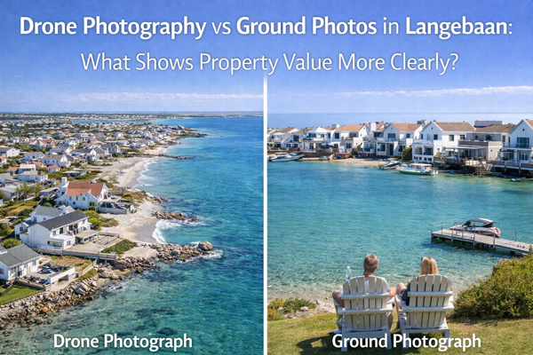
Ground vs Drone Property Photos: A Value Comparison
When comparing ground vs drone property photos, the difference is not quality—it is perspective.
Ground photos explain what the property looks like inside
Drone photos explain why the location adds value
Buyers evaluating what shows property value better are not choosing between the two. They are subconsciously combining them.
Listings that use both formats answer more questions upfront, which improves enquiry quality and reduces time wasted on unsuitable viewings.
Location Context and Buyer Confidence
In coastal towns, showing location in property marketing is a value signal in itself. Buyers paying coastal premiums expect transparency.
Drone imagery allows buyers to understand:
How close the property is to the beach
Whether views are protected or obstructed
How private or exposed the plot is
This is particularly relevant in areas like Blue Lagoon and Langebaan Country Estate, where lifestyle positioning is a major pricing factor.
Clear location visuals improve property photography buyer trust by removing suspicion and uncertainty.
Buyer Perception and Emotional Response
Research into buyer perception real estate photos consistently shows that clarity reduces emotional resistance.
Drone images create:
A stronger sense of place
Emotional reassurance about surroundings
Confidence that nothing important is being hidden
This directly influences how photos affect property value perception. Buyers who feel informed are more likely to accept asking prices as reasonable rather than inflated.
Expectation-Setting Before Viewings
One overlooked advantage of aerial photography coastal properties is expectation management.
When buyers arrive already understanding:
Plot size
Neighbour proximity
Orientation and surroundings
Viewings become more productive. Fewer buyers walk away due to unexpected location issues, which protects seller confidence and agent credibility.
Supporting Premium Coastal Pricing
Premium pricing requires visual justification. Coastal property drone photography supports higher price points by clearly demonstrating:
Superior positioning
Access to lifestyle features
Spatial advantages competitors may lack
Drone photos do not exaggerate value. They anchor price to visible reality, which is essential in competitive coastal markets.
Why the Answer Is Not Drone or Ground
From a marketing strategy perspective, drone photography vs ground photography is a false choice.
Ground photos sell the home
Drone photos sell the setting
Together, they create a complete, transparent value narrative—especially important in Langebaan coastal property marketing and across the West Coast.
Final Thoughts:
Ground photography shows buyers what they are buying.
Drone photography shows them why it is worth the price.
If your goal is to communicate value clearly, reduce buyer uncertainty, and support confident pricing, combining ground photography with drone photos coastal real estate is not optional. It is the most accurate way to present property value in Langebaan’s coastal market.
