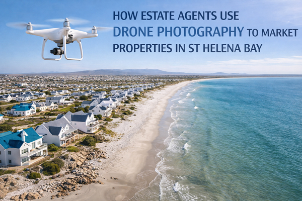
How Estate Agents Use Drone Photography to Market Properties in St Helena Bay
Property marketing works best when buyers can quickly understand what they are being shown. In coastal towns, that understanding depends as much on location and setting as it does on the house itself.
In St Helena Bay, buyers are not only comparing interiors. They are comparing spacing, surroundings, and how a property fits into the wider area. This is why drone photography real estate has become a practical tool for estate agents who want their listings to feel clear, credible, and professionally marketed.
The Marketing Challenge Estate Agents Face
Most listings still rely heavily on ground-level images. These are excellent for showing finishes and condition, but they struggle to explain context.
Buyers want to know:
Where the property sits in relation to others
How open or enclosed the area feels
Whether location justifies the asking price
How the home fits into a coastal lifestyle
Without this information, buyers hesitate. Hesitation leads to scrolling, saving for later, or moving on to another listing that feels easier to understand.
This is where real estate drone photography becomes a strategic advantage rather than a visual extra.
Why Aerial Property Photography Matters in Coastal Markets
Aerial property photography gives buyers something they cannot get from interior images alone. It explains scale, layout, and surroundings in seconds.
For estate agents, drone imagery allows them to:
Show the full footprint of a property
Reveal plot boundaries and orientation
Demonstrate spacing between homes
Provide visual context for location
In coastal towns, where setting strongly influences value, this context is critical.
How Drone Photos Improve Property Marketing
Understanding how drone photos improve property marketing comes down to confidence.
When buyers can clearly understand where a property sits, they feel more confident engaging with the listing. That confidence translates into better-quality enquiries and more focused viewings.
Drone photos for property marketing help to:
Improve first impressions on portals
Reduce uncertainty before enquiries
Attract buyers who already understand the location
Support faster decision-making
This is especially important in property marketing St Helena Bay, where many buyers are viewing properties remotely.
Showing Property Location With Drone Photos
Maps and written descriptions are useful, but they are not intuitive. Buyers prefer visual explanations.
Showing property location with drone photos allows estate agents to communicate:
Street layout and access routes
Relationship to neighbouring properties
Proximity to open land or coastal areas
Overall feel of the surrounding area
This clarity reduces the need for explanation and prevents misunderstandings before viewings take place.
Aerial Photos for Coastal and Lifestyle Property Marketing
Coastal homes are often sold on lifestyle as much as structure. Openness, space, and setting matter.
Aerial photos for coastal property and drone photography for lifestyle property help buyers visualise how the home fits into daily life, not just how it looks inside.
This makes property listing aerial photography particularly effective for:
Lifestyle-driven buyers
Out-of-area purchasers
Buyers comparing similar homes
The result is stronger engagement with listings that feel more complete.
Supporting a Strong Estate Agent Photography Strategy
Drone imagery works best when it forms part of a broader estate agent photography strategy.
Combined with strong interior photography, aerial images help create a cohesive marketing package. Together, they support professional real estate photography that feels deliberate rather than pieced together.
This consistency strengthens brand perception and signals that the agent takes presentation seriously.
Building Trust Through Transparency
Trust is one of the most powerful drivers in property marketing.
Listings that include aerial imagery feel more transparent. Buyers can see the surrounding context rather than wondering what has been left out. This openness builds credibility and reduces scepticism.
Across the West Coast, real estate aerial photography marketing has become a signal of professionalism rather than extravagance.
Local Relevance in St Helena Bay and the West Coast
In regional markets, context matters more than in dense cities. Plot size, spacing, and surroundings play a large role in perceived value.
Drone photography St Helena Bay allows estate agents to showcase these factors clearly, while real estate drone photography West Coast has become an increasingly expected standard.
This aligns with broader expectations around property photography South Africa, where buyers now assume aerial context will be part of quality marketing.
A Confident Closing
Drone photos strengthen property marketing in St Helena Bay by adding clarity, context, and credibility. They help buyers understand where a property sits, how it relates to its surroundings, and whether it fits their needs before they enquire.
For estate agents, drone photography real estate South Africa is no longer about novelty. It is about meeting modern buyer expectations and communicating value clearly.
If your property marketing needs to feel more professional, more transparent, and more effective, drone photography is not an optional upgrade.
It is part of what strong property marketing looks like today.
